The Gallatin River
Overview
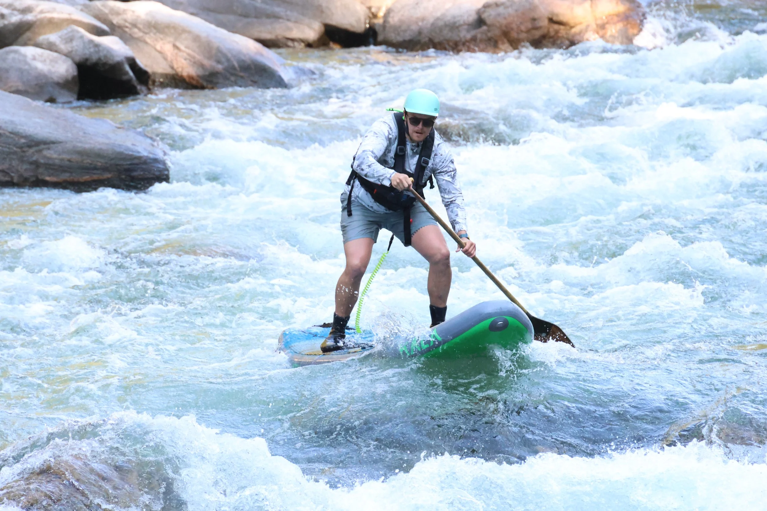
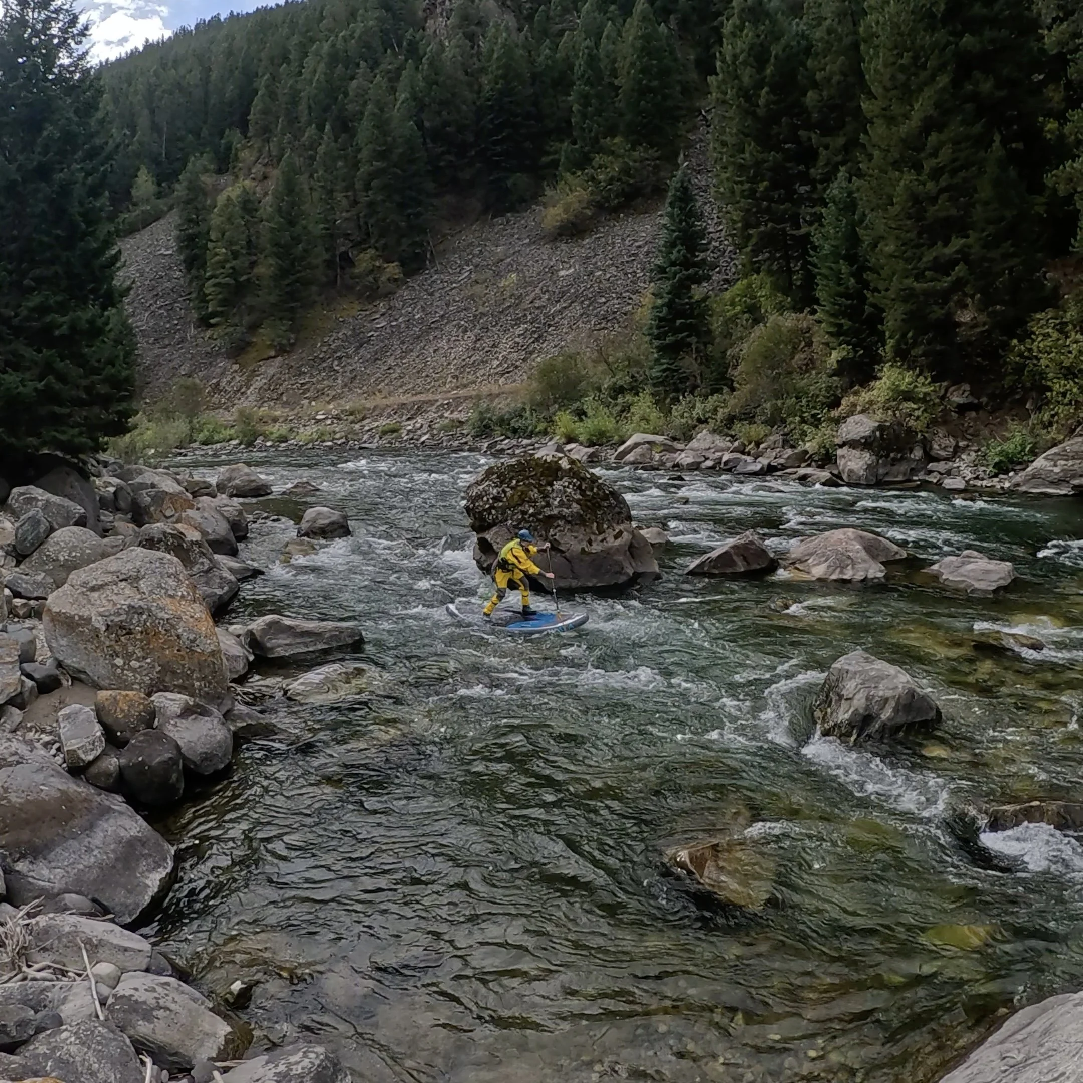
The Gallatin River in Montana is a dream spot for whitewater paddle boarding and this entry will focus on its whitewater sections from the Deer Creek trailhead to Upper Storm Castle Boat Launch. This stretch of river is sectioned into two different runs, colloquially known as the Upper (II-III) and Lower section or The Mad Mile (III-IV flow dependent) of the Gallatin River.
Winding through the stunning Gallatin Canyon, with its clear waters, surrounded by rugged cliffs and dense forests, the Gallatin gives you both a thrilling ride and breathtaking views. Whether you're up for tackling some Class III rapids or want some tamer I’s and II’s, the Gallatin River has something for every whitewater SUP Rider.
River Details & CFS Analysis
River Gauge: Gallatin River near Gallatin Gateway, MT - 06043500
American Whitewater Link: Greek Creek to Spanish Creek (House Rock)
CFS Level and Difficulty Chart
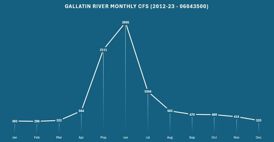
Monthly CFS Averages 2012-2023 Charts
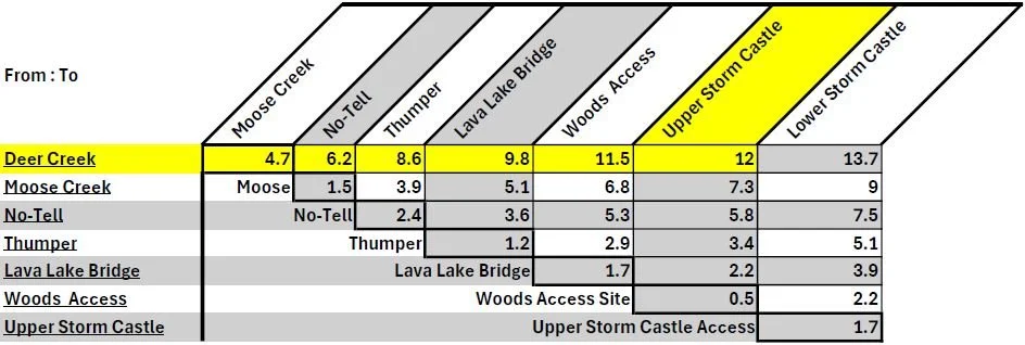
River Miles and Access Locations
*Upper Section - Anything from Deer Creek to Lava Lake (35 mph Bridge)
*Lower Section - From Lava Lake (35 mph Bridge) to Upper Storm Castle
Put-In Locations:
Deer Creek (Green Bridge) - Mile 0
GPS Coordinates: 45.298934, -111.203994
Moose Creek Flats Campground - Mile 4.7
GPS Coordinates: 45.356796, -111.171570
No-Tell Access - Mile 6.2
GPS Coordinates: 45.376602, -111.174489
Thumper Rapid Access - Mile 8.6
GPS Coordinates: 45.395637, -111.208748
Lava Lake (35 mph Bridge) - Mile 9.8
GPS Coordinates: 45.407118, -111.224937
Take-Out Location:
Woods Kayaker Access - Mile 11.5
GPS Coordinates: 45.428884, -111.232651
Upper Storm Castle Creek - Mile 12
GPS Coordinates: 45.435871, -111.232651
Lower Storm Castle Creek - Mile 13.7
GPS Coordinates: 45.457165, -111.245568
Upper Section (Deer Creek to Lava Lake Parking)
Deer Creek Trailhead and Launch Site*
· Start your adventure here, where the river is wide and welcoming, setting the stage for what's to come.
Sheep Eater Rapid (Mother Eater Rapid)
· Description: The first rapid encountered after your put in. The river turns left into an eddy against the cliff before doglegging back down a couple drops.
· Historic Note: Named after the Shoshone tribe, specifically the Tukudeka, or Mountain Sheep Eaters, whose artifacts were found here when the road was built.
· Wildlife: Watch for Big Horn Sheep that often cross near the rapid.
· Legend: One guide rescued a sheep caught in the rapid's notorious eddy by lassoing it to safety. Another tale speaks of a guide who accidentally dumped his mother here, hence the name "Mother Eater."
Marker Rock (William Wallace)
· Significance: Seeing this rock signals that the "guide ejector" is active at Portal Creek.
Portal Creek Rapid
· Description: A rapid that belongs in the Mad Mile but hasn't quite accepted its fate yet.
· Legend: Named for the petrified wood that comes into the Gallatin or that swimming here feels like being sent through a portal.
Durnam Meadows
· Historic Note: This land passed from public to private ownership under the Homestead Act of July 28, 1916. Ed and Isabelle Durnam purchased the land in 1936.The Durnam family raised head lettuce here for almost 30 years. Lettuce was irrigated with Gallatin River water preserved with ice cut from the river in winter and shipped to markets throughout Montana in crates made from local timber cut in the Durnam’s small sawmill. When lettuce farming became uneconomical, the Durnams raised Hereford cattle until Mr. Durnam’s death in 1970.This and the surrounding land is choice wildlife habitat. Because of her love for animals and for the land, Mrs. Durnam wished to return this land to the National Forest. Accordingly this land was purchased with Land and Water Conservation funds in 1978.
Karst Camp Area and Launch Site*
· Historical Note: Formerly the headquarters for Yellowstone Rafting.
Moose Creek Flats Launch Site*
· Location: Moose Creek Flats is located on river right and was historically used as a parking lot for an asbestos mine. The area was once part of the Karst property.
· Access Point Details: This is a popular access point for paddlers looking to start their journey on this stretch of the Gallatin River. Putting in at Moose Creek Flats offers a bit of warm-up time before encountering the more challenging rapids of the Mad Mile downstream. It's a convenient and frequently used spot for launching your paddleboarding adventure
Lonesome Wave
· Description: A stand-alone wave that offers great surfing if you hit the right flow.
Swan Creek Confluence
· Details: An S-turn with surfable sections at higher water levels; Swan Creek enters from river right.
No-Tell Boat Launch Site*
· A more secluded spot for accessing the river.
No-Tell Rapid
· A fun, boulder-dodging rapid that's trickier at lower water levels.
Greek Creek Campground and Launch Site*
· Access: River right; not a day-use area, but a good place to start your journey. Park in a pull off if accessing here. There is no day parking.
Ender’s Hole Rapid
· Note: This rapid no longer exists after the river shifted in 2012, creating a new S-turn channel.
Beers from Heaven (formerly Beer Truck Alley or Barbie's Revenge)
· Naming History: This rapid has a colorful history with multiple names. Geyser Rafting refers to it as "Beers from Heaven," while Montana Whitewater Rafting Guides still call it "Beer Truck Alley."
· Legend: The name "Beer Truck Alley" originates from an incident in 2003 when a refrigerated beer truck crashed on the road above the river, injuring seven people. The crash occurred at 1:30 PM, right in the middle of rafting safety talks. Mikey Benevento, a rafting guide, skillfully boofed his raft onto the truck's windshield, allowing the truck driver to climb aboard and escape safely. For the next three days, rafting guides used nets to fish out beer from the river for their clients.
· Current: Beers from Heaven is now a Class III rapid that presents a fun wave train at medium-high flows. At lower water, rocks start to appear, closing off the center line, making navigation trickier. The rapid remains a favorite spot, steeped in local rafting lore
Old Car/Picture Rock Rapid
· Name Origin: This rapid gets its name from the old Model T cars that were once placed along the riverbank for erosion control, giving it a unique historical touch.
· Current Conditions: At higher water levels, there’s a maneuver known as "Doggy Style" where you can navigate left, but it requires caution due to a sieve downstream that can "taco" an entire boat, causing a chaotic scramble among paddlers.
· Navigation Tips: Approach this rapid by entering right-of-center, then work your way to the left. Keep an eye out for a large pourover or hole that forms at medium flows, which can catch you off guard if you’re not careful.
New Rock (Zell's Hell)
· Origin: Created by a landslide in 1996, this rapid shifts after each big water year.
Screaming Left Rapid
· Visual Marker: This rapid is easily identified by a distinctive rock formation above it, which some say resembles Chief Joseph of the Nez Perce tribe, complete with a tree on top that looks like a feather in his headdress. Others see a gorilla in the rock’s shape, adding to its mystique.
· Current Conditions: Screaming Left is a Class III- rapid, marked by a cliff on the left side of the river. At lower water levels, most paddlers navigate by entering on the left side. However, at higher water, a large and powerful hole forms at the bottom, known as the "Catcher’s Mitt," which can be challenging to avoid. This rapid has a reputation for flipping boats, so careful navigation is essential.
Bambie Rapid
· A smaller, yet memorable, rapid in the lineup.
Thumper Launch Site*
· A convenient access point for warming up before the Mad Mile.
Thumper Rapids
· Rapid Sequence: Thumper Rapids is a Class III stretch with a series of challenging holes and waves that demand your full attention. This rapid is known for its sequence of features that give it its name:
o Thumper: A large, gravestone-like rock that gives a solid "thump" at high water, requiring precise maneuvering.
o Dumper: A hidden rock that often surprises paddlers, making it a notorious spot for an unexpected swim—especially if someone in the group needs a little humbling.
o Bumper: A playful rock where you can roll up and peel off, offering a great photo opportunity for friends.
· Navigation Tips: Keep alert and square up to each wave and hole as you navigate this rapid. The sequence of Thumper, Dumper, and Bumper makes for an exciting and dynamic stretch of the river, perfect for those looking to test their skills..
Cascade Creek Confluence
· Location: The Cascade Creek Confluence is located on the left-hand side of the Gallatin River.
· Description: Cascade Creek originates from Lava Lake and braids into seven distinct waterfalls before merging with the Gallatin. These waterfalls, known as the Seven Sisters Falls, carry a somber history. They are named after seven nuns who traveled to the area to preach Christianity to the Blackfoot Indians, only to meet a tragic end. The confluence marks a significant and scenic point along the river, where the cascading waters of Cascade Creek add to the Gallatin’s flow and natural beauty.
·Extreme Straightaway Rapid and Killer Fang Falls
· Class III: Be prepared to T-up larger waves at higher water; lower flows offer a drop between two center rocks.
Catbox Rapid
· Surfing: A ledge hole forms at medium flows, ideal for rafts.
Lava Lake Boat Launch Site*
· Location: Just above the US Highway 191 bridge, marking the start of the Mad Mile.
· Take-Out: This is the takeout for those who don’t want to continue down the Mad Mile
Lower Section (Mad Mile)
Put-In
You can put-in at any access point above Lava Lake, however, if you just want to run hot laps of the Mad Mile, Lava Lake is the place to start.
Lava Lake Location: Just above the US Highway 191 bridge at the top of the parking lot on the right marks the start of the Mad Mile.
Entrance Exam Rapid
Overview: Entrance Exam is the first rapid in the Mad Mile, marking the start of this challenging stretch with a series of splashy waves and holes. It's aptly named "Entrance Exam" because it sets the tone for the Mad Mile with a "pass or fail" grade, testing your readiness for what's to come.
Navigation Tips: As you approach, be mindful of the bridge downstream—avoid getting too close to the pylons. The rapid has two main lines:
River Right: Known as "Satan’s Gut" or "Jaba’s Palace," this line involves navigating between two significant rocks. The larger rock is "Jaba the Hut," and the smaller one is "Salacious B. Crumb," Jaba’s pet.
River Left: Most paddlers aim to pass between these two rocks. A 14-foot raft can fit, but anything larger may struggle.
Challenge: Successfully navigating Entrance Exam is key to setting yourself up for the rest of the Mad Mile. Approach with focus and precision to ensure a smooth start to this demanding section of the Gallatin River
US Highway 191 Bridge
Feature: Navigate carefully under the bridge as you continue down the Mad Mile.
Showstopper/Pinball (Class II)
Overview: Located just below the bridge, this rapid features a rock garden that presents two primary lines for navigation.
Pinball Line (Right): The Pinball line on the right side of the rapid requires careful maneuvering around the rocks, as there is a sieve on the far right that should be avoided.
Showstopper Line (Left): On the left side, at higher flows, a significant hole known as the Showstopper forms. This line is named after the large rock that dominates this section—be careful not to confuse it with House Rock, which is located further downstream.
Challenge: While this rapid is Class II, the combination of the rock garden, sieve, and the potential for a powerful hole at higher water levels makes it an engaging and technical part of the river. Choose your line carefully based on the water flow and your skill level.
Old Bridge Rapid
Class III: Enter on the right, punching through waves and working your way left.
Old Bridge Crossing
Landmark: The remnants of an old bridge crossing the Gallatin River.
Flow Tip: At higher flows (1400+) a fun double pool drop forms on the left side of the center rock island.
Snaggletooth Rapid
Name Origin: Snaggletooth is whimsically named after an old rafter’s girlfriend from New Hampshire. The rapid gets its name because the rocks in this area resemble a set of jagged teeth.
Navigation Tips: As you approach Snaggletooth, aim to enter left of center. Be especially cautious of the barely exposed rock that emerges on the right side, which can catch paddlers off guard. This rock adds to the "toothy" appearance of the rapid and requires careful maneuvering to avoid.
Two Scoops Rapid (Class III)
Overview: Two Scoops is a Class III rapid that becomes significantly more challenging at high water, where it begins to flirt with Class IV conditions.
High Water Conditions: When the river flow exceeds 6500 CFS, two massive, river-wide holes form in this rapid. These "boat-sucking" holes demand precise navigation.
Navigation Tips: At high flows, it’s crucial to stay far left, even skirting into the pine trees along the bank, to avoid these powerful holes. The name "Two Scoops" reflects the dual challenge presented by these formidable features, making this rapid a serious test for paddlers during peak conditions.
Safety Eddy
A good spot to regroup above House Rock Rapid.
House Rock (III-III+)
Overview: House Rock Rapid is a Class III+ challenge that demands careful scouting and patience. The rapid is defined by a large rock, House Rock, located in the center of the river, with several key features that require precise navigation.
Navigation Tips: The line to take for House Rock differs depending on flows.
Low Water (400-600 CFS) - There are two lines into House Rock at this level.
River Left Line - Stay along the left bank and make a left turn into a small eddy, redirect your nose back to the right and take the small tongue drop pointed towards House Rock.
River Right Line - Stay in the middle of the flow until you reach a large eddy on the right side of the river. Pull into the eddy and take the two drop line into the water above House Rock, pulling back to the left through House Rock proper. The right channel past House is restricted by a rock wall at these flows and cant be run.
Mid (600-1800 CFS)
Middle Boof - Stay in the middle flow and boof the drop that forms to the left of Whacker
High (1800-2200)
Left Shore - Take the left side through the action. Higher flows allow you to continue left through the entire Boulder Garden as well.
Highest Recorded Standing Run of House Rock - 2200 CFS
· Key Features:
o Whacker: Positioned above House Rock, this feature can pull you toward House Rock if you don’t manage your line carefully. Aim to pass left of this hole to avoid being pushed into trouble.
o Pappouse Rock: This rock leans against House Rock and causes a significant wave, known as "China Man," on the left side. You'll want to navigate carefully to avoid being caught by this wave
o V Wave: Just below House Rock, you’ll encounter a large curler wave that requires solid control to navigate.
House Rock Video Edit
Boulder Garden: Below House Rock, a boulder garden presents additional challenges, especially at higher water levels. The far-right side of the garden is known as "Mitch’s Ditch," a route explored extensively by a Montana Whitewater guide during his first season. The boulders in this section have their own names—The Hamburger Stand, The Motel 6, The Mail Slot, and The Anvil—each presenting unique obstacles.
Navigation Tips: The safest route through the boulder garden, particularly when the flow is above 2,000 CFS, is generally down the left side. However, be cautious of logs that often get trapped next to The Anvil Rock, creating potential hazards. House Rock Rapid requires a strategic approach, making it one of the more technically demanding sections of the Gallatin River.
Rodeo Rapid (Class II+)
Overview: Rodeo Rapid is a Class II+ rapid that becomes more challenging at higher water levels due to the formation of the Rodeo Hole.
High Water Conditions: At higher flows, the Rodeo Hole can grow significantly in size, making it a feature to be cautious of. The recommended route is to stay left of the hole at most water levels to avoid being caught in its powerful pull.
Safety Tips: Just below the rapid, there is a Safety Eddy on the right side, providing a good spot to regroup and catch your breath after navigating the rapid. This feature makes Rodeo Rapid a manageable yet engaging section of the river, especially as water levels rise.
Davy Jones Hole
Overview: Davy Jones is a significant and formidable hole that forms on river right at high water, just below an overhanging tree.
High Water Conditions: When water levels are high, this hole becomes quite large and powerful. To avoid getting caught in Davy Jones, it’s crucial to stay centered in the river as you pass through this section.
Lower Water Levels: As the water drops, Davy Jones transforms:
Granny Popper: At moderate levels, the hole is less intense but still tricky, earning the nickname Granny Popper.
Beans Bean: At even lower water, the rapid becomes known as Beans Bean. This name comes from a guide named Bean at Montana Whitewater, who notoriously hit the rocks in this section, often causing clients to take an unexpected swim.
Navigation Tips: Whether dealing with Davy Jones at high water or its lower water variants, staying centered and vigilant is key to successfully navigating this rapid without incident
Gagoosh Rapid (Class III)
Overview: Gagoosh Rapid is a Class III, read-and-run rapid that requires paddlers to square up to the waves as they navigate through.
Key Features: The rapid is straightforward but demands attention to properly align with the waves for a smooth run.
Navigation Tips: Approach Gagoosh with a focus on maintaining a solid line through the waves, and take advantage of the Cathedral Eddy below to pause and soak in the surroundings, or to regroup if needed.
The Cathedral Eddy: Just below Gagoosh, you'll find an eddy known as the Cathedral, named for the impressive cliff that rises alongside it. This spot is notable not only for its scenic beauty but also for its special significance to the rafting community—some guides have even chosen this location for their wedding ceremonies. The eddy is directly across from the prominent Gallatin Tower, adding to the dramatic setting.
Popeyes Rapid
· Name Origin: Named after a rock resembling Popeye's arm.
Prudential Rapid (Class III-)
· Overview: Prudential Rapid is characterized by a prominent rock on the right side of the river, which is the rapid's namesake.
· Key Features: As you approach the rapid, you'll notice a large rock that resembles the Prudential logo on the bottom right. At higher water levels, this rock can form a significant hole or wave, making it a feature to avoid.
· Navigation Tips: The primary challenge in Prudential Rapid is steering clear of the Prudential rock. You'll want to work your way away from this feature, especially at higher flows, to ensure a smooth passage through the rapid
Magnet Rock Rapid (Wall of Destruction)
Class III: Work to stay in the center and avoid the left side's pull toward Magnet Rock.
Surf Holes
Numerous surf holes for play boating.
Upper Storm Castle Take-Out*
River Left: The most commonly used take-out, marking the end of the intense whitewater.
You can continue down below this to Lower Storm Castle. At high water this is worth the additional distance.
Storm Castle Creek
River Right: A scenic spot with great hiking opportunities.
Hell Roaring Creek Confluence
River Left: The spot where they filmed the iconic scene from "A River Runs Through It."
Lower Storm Castle Take-Out*
River Left: Beyond this, the river mellows out into Class I/II riffles.
Acknowledgements
This entry was only possible through the wisdom of Ethan Greaves at Montana Whitewater. Ethan’s face is one of the most prevalent in the canyon, always branded with an ear to ear smile and a contagious energy.
Additionally the time spent understanding the river by the following paddle boarders allowed for a detailed analysis of the sections tailored for standup paddle boaring rather than a focus of other crafts.
Chad Dokken, Björn Borg, Ted Grover, Thomas Jackson
Many of this entry can be utilized for other crafts (kayak, canoe, raft) but commentary about lines is more specific to SUP.


